Mapping Our Past is a behind-the-scenes look into how historic maps illuminate our past and continue to guide researchers in the modern day. Perfect for map enthusiasts, history buffs, lifelong learners, and students, this annual event celebrates the Lewis Ansbacher Map Collection, which is on permanent display for the public in Special Collections at the Main Library and accessible via the Digital Collection.
SAVE THE DATE: Join us from 10 a.m. to 12:30 p.m. on Saturday, Jan. 16, 2027, on the fourth floor of the Main Library. This year's event includes two expert-led lectures exploring American history, the changing landscape of our state, the evolution of cartography, and ongoing research and preservation efforts.
# Schedule of Events
#
The Florida Territory: From Outpost to Statehood
10 - 11 a.m., Ansbacher Map Room
with Rodney Kite-Powell, Tampa Bay History Center
Explore Florida’s time as a U.S. territory (1821–1845) and how its history mirrored national events leading up to the Civil War. The program uses historic maps to trace Florida’s territorial period and show how it foreshadowed later U.S. history, particularly the themes and events that shaped the American West after the Civil War. It highlights how Florida’s political, economic, and social developments during this era reflected broader national trends.
RSVP for "The Florida Territory"
#
Unearthing the Past Through Maps: How Maps Reveal (and Conceal) History
11:30 - 12:30 p.m., Ansbacher Map Room
with Susan Schulten, University of Denver
Over five hundred years, America has been defined through maps. Whether handmaidens of diplomacy, tools of statecraft, instruments of social reform, or tools of persuasion, these sources record efforts to make sense of the world and reflect decisions about how the world ought to be seen. In this presentation, you'll see some of the maps that have shaped the history of North America, particularly the Southeast and Florida.
RSVP for "Unearthing the Past..."
Please note: You must register for each program individually if you plan to attend both programs.
Mapping our Past is made possible through the generosity of the Lewis and Sybil Ansbacher Family Foundation and the Jordan and Shirley Ansbacher Family Foundation through the Library Foundation of Jacksonville.
# Schedule a Tour
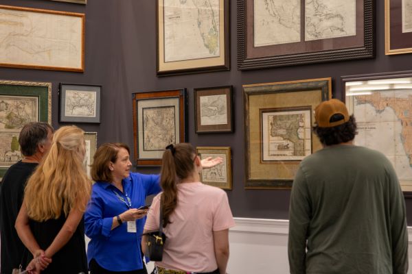
The Lewis Ansbacher Map Collection features 172 antiquarian maps from around the world as well as two dozen prints with historical views and plates focusing on North Florida. Spanning from 1522 to 1932, this historically significant collection offers a visual narrative of the evolving boundaries of the early colonies, the emergence of state jurisdictions, and the development of infrastructure. Guided tours of the Morris Ansbacher Map Room are available, as well as an interactive touchscreen offering detailed views.
Around the corner, the Jordan & Shirley Ansbacher Gallery houses the Le Moyne/DeBry Collection, a sub-collection of the Map Collection, comprised of 43 engravings. Drawn by artist Jacques Le Moyne during Laudonniere’s expedition and engraved and published by Theodor De Bry in 1591, they depict the earliest known visual representations of Florida and its Indigenous People.
Visit jaxlibrary.org/MapRoom to schedule a tour or to view the collection online.
# About Our Expert Speakers
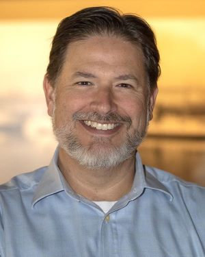
Our first guest, Rodney Kite-Powell, is the Director of the Touchton Map Library at the Tampa Bay History Center. He received a Bachelor of Arts from the University of Florida and a Master of Arts from the University of South Florida, both in U.S. History. He has lectured on state and local history and is the author of three books including: History of Davis Islands: David P. Davis and the Story of a Landmark Tampa Neighborhood and Tampa Bay’s Waterfront: Its History and Development.
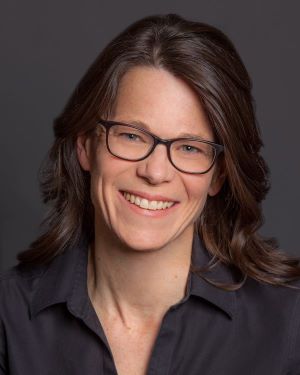
Our second guest, Susan Schulten, is Distinguished University Professor of History at the University of Denver, where she has taught since 1996. She served as the Colorado State Historian this past year, which marked 150 years of Colorado Statehood and 250 years of American independence. Professor Schulten’s courses include Understanding Lincoln, the Civil War and Reconstruction, War and the Presidency, American Thought and Culture, and Nineteenth-Century America.
# Further Reading
Schulten is the author of several books that use old maps to tell new stories about American history, including A History of America in 100 Maps (2018), Mapping the Nation: History and Cartography in Nineteenth-Century America (2012), and The Geographical Imagination in America, 1880-1950 (2012), all published with the University of Chicago Press. Her most recent book is Emma Willard: Maps of History (2022).
Sculten has also co-authored a two-volume history of America with Elliott Gorn entitled Constructing the American Past: A Sourcebook of a People’s History (9th edition, 2024) with Oxford University Press. Her work has been funded by the Guggenheim Foundation, the National Endowment for the Humanities, and the Mellon Foundation. She is now writing a book about one of the most influential mapmakers of the twentieth century, Richard Edes Harrison.